https://www.britannica.com/science/iceberg/Iceberg-detection-tracking-and-management
An Iceberg is a floating mass of freshwater ice that has broken from the seaward end of either a glacier or an ice shelf. Icebergs are found in the oceans surrounding Antarctica, in the seas of the Arctic and subarctic, in Arctic fjords, and in lakes fed by glaciers.
ICEBERG TYPES
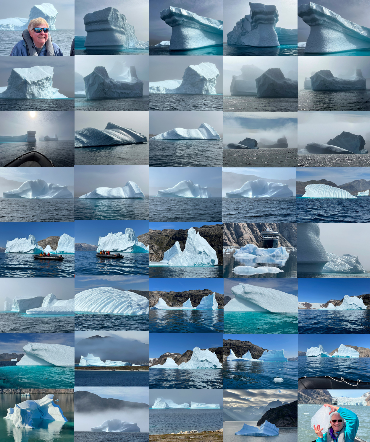
Tabular, Wedge, Drydock, Dome, Pinnacled and Blocky
Most Arctic icebergs originate from the fast-flowing glaciers that descend from the Greenland Ice Sheet. The irregularity of the bedrock and valley wall topography both slows and accelerates the progress of glaciers. These stresses cause crevasses to form, which are then incorporated into the structure of the icebergs. Arctic bergs tend to be smaller and more randomly shaped than Antarctic bergs and also contain inherent planes of weakness, which can easily lead to further fracturing. If their draft exceeds the water depth of the submerged sill at the mouth of the fjord, newly calved bergs may stay trapped for long periods in their fjords of origin. Such an iceberg will change shape, especially in summer as the water in the fjord warms, through the action of differential melt rates occurring at different depths. Such variations in melting can affect iceberg stability and cause the berg to capsize. Examining the profiles of capsized bergs can help researchers detect the variation of summer temperature occurring at different depths within the fjord. In addition, the upper surfaces of capsized bergs may be covered by small scalloped indentations that are by-products of small convection cells that form when ice melts at the ice-water interface.
The Arctic Ocean's equivalent of the classic tabular iceberg of Antarctic waters is the ice island. Ice islands can be up to 19 miles long but are only 200 feet thick. The main source of ice islands used to be the Ward Hunt Ice Shelf on Canada’s Ellesmere Island near northwestern Greenland, but the ice shelf has been retreating as ice islands and bergs continue to calve from it. (The ice shelf is breaking into pieces faster than new ice can be formed.) Since the beginning of observations in the 1950s, the Ward Hunt Ice Shelf has virtually disappeared. The most famous of its ice islands was T-3, which was so named because it was the third in a series of three radar targets detected north of Alaska. This ice island carried a manned scientific station from 1952 to 1974. Ice islands produced by Ellesmere Island calve into the Beaufort Gyre (the clockwise-rotating current system in the Arctic Ocean) and may make several circuits of the Canada Basin before exiting the Arctic Ocean via Fram Strait (an ocean passage between Svalbard and Greenland).
A third source of ice islands, one that has become more active, is northeastern Greenland. The Flade Isblink, a small ice cap on Nordostrundingen in the northeastern corner of Greenland, calves thin tabular ice islands with clearly defined layering into Fram Strait. Observations in 1984 showed 60 grounded bergs with freeboards of 40-50 feet off Nordostrundingen in 120-175 feet of water. Similar bergs acted as pinning points for pressure ridges, which produced a blockage of the western part of Fram Strait for several years during the 1970s. In 2003 the multiyear cover of fast ice (see sea ice) along the northeastern Greenland coast broke out. This allowed a huge number of tabular icebergs to emerge from the fast-flowing Nioghalvfjerdsfjorden Glacier and Zachariae Isstrom in northeastern Greenland. Some of these reached the Labrador Sea two to three years later, while others remained grounded in 260–360 feet of water on the Greenland shelf.
Iceberg structure
A newly calved Antarctic tabular iceberg retains the physical properties of the outer part of the parent ice shelf. The shelf has the same layered structure as the continental ice sheet from which it flowed. All three features are topped with recently fallen snow that is underlain by older annual layers of increasing density. Annual layers are often clearly visible on the vertical side of a new tabular berg, which implies that the freeboard of the iceberg is mainly composed of compressed snow rather than ice. Density profiles through newly calved bergs show that at the surface of the berg the density might be only 25 pounds per cubic foot, pure ice has a density of 57 pounds per cubic foot, and both air and water may pass through the spaces between the crystal grains. Only when the density reaches 50 pounds per cubic foot deep within the berg do the air channels collapse to form air bubbles. At this point, the material can be properly classified as ice, whereas the lower-density material above the ice is more properly called firn. Corresponding to a layer some 150-200 years old and coinciding approximately with the waterline, the firn-ice transition occurs about 130-200 feet below the surface of the iceberg. Deeper still, as density and pressure increase, the air bubbles become compressed. Within the Greenland Ice Sheet, pressures of 10-15 atmospheres (10,100–15,200 millibars) have been measured; the resulting air bubbles tend to be elongated, possessing lengths up to 0.2 inch and diameters of 0.0008–0.007 inch. In Antarctic ice shelves and icebergs, the air bubbles are more often spherical or ellipsoidal and possess a diameter of 0.01-0.02 inch. The size of the air bubbles decreases with increasing depth within the ice.
Iceberg size and shape
For many years, the largest reliably measured Antarctic iceberg was the one first observed off Clarence Island (one of the South Shetland Islands) by the whale catcher Odd I in 1927; it was 110 miles long, was approximately square, and possessed a freeboard of 100–130 feet. In 1956 an iceberg was sighted by USS Glacier off Scott Island (a small island (about 300 miles northeast of Victoria Land in the Ross Sea) with unconfirmed length of 210 miles and width 60 miles. However, recently there have been many calvings of giant icebergs in the Ross and Weddell seas with dimensions that have been measured accurately by satellite. In 2000 iceberg B-15 broke off the Ross Ice Shelf with an initial length of about 185 miles. Although B-15 broke into two fragments after a-few days, B-15A-the larger portion, measuring 75 miles long by 12 miles wide-obstructed the entrance to McMurdo Sound and prevented the pack ice in the sound from clearing out in the summer. In October 2005 B-15A broke up into several large pieces off Cape Adare in Victoria Land because of the impact of distant swell. Iceberg C-19 was an even larger but narrow iceberg that broke off the Ross Ice Shelf in May 2002. It fragmented before it could drift far.
Iceberg Size ~ Categories
Growler < 3 feet high < 16 feet long
Bergy bit 3 to 13 15 to 46
Small berg 14 to 50 47 to 200
Medium berg 51 to 150 201 to 400
Large berg 151 to 240 401 to 670
Very large berg > 240 > 670
Arctic bergs are generally smaller than Antarctic bergs, especially when newly calved. The largest recorded Arctic iceberg (excluding ice islands) was observed off Baffin Island in 1882; it was 8 miles long by 4 miles wide and possessed a freeboard, or the height of the berg above the waterline, of 65 feet. Most Arctic bergs are much smaller and have a typical diameter of 330-1,000 feet. Owing to their origin in narrow, fast-flowing glaciers, many Arctic bergs calve into random shapes that often develop further as they fracture and capsize. Antarctic bergs also evolve by the erosion of the weak freeboard or via further calving into tilted shapes. Depending on the local shape of the ice shelf at calving, the surfaces of icebergs, even while still predominantly tabular, may be domed or concave.
ICEBERG TYPES
Tabular, Wedge, Drydock, Dome, Pinnacled and Blocky
Arctic icebergs often suffer from repeated capsizes - there is no special layer of weak material. Instead, the whole berg gradually melts at a rate dependent on the salinity (the salt concentration present in a volume of water) and temperature at various depths in the water column and on the velocity of the berg relative to the water near the surface.
In Arctic icebergs, erosion often leads to a loss of stability and capsizing. For an Antarctic tabular berg, complete capsize is uncommon, though tiltmeter measurements have shown that some long, narrow bergs may roll completely over a very long period. More common is a shift to a new position of stability, which creates a new waterline for wave erosion. When tabular icebergs finally fragment into smaller pieces, these smaller individual bergs melt faster, because a larger proportion of their surface relative to volume is exposed to the water.
Scoresby Sund
In the Arctic Ocean, the highest latitude sources of icebergs are Svalbard archipelago north of Norway and the islands of the Russian Arctic. The iceberg production from these sources is not large-an estimated 1.5 cubic miles per year in a total of 60-110 cubic miles for the entire Arctic region. An estimated 26 percent originates in Svalbard, 36 percent stems from Franz Josef Land, 32 percent is added by Novaya Zemlya, about 6 percent begins in Severnaya Zemlya, and 0.3 percent comes from Ushakov Island. Many icebergs from these sources move directly into the shallow Barents or Kara seas, where they run aground. Looping trails of broken pack ice are left as the bergs move past the obstacles. Other bergs pass through Fram Strait and into the East Greenland Current. As these icebergs pass down the eastern coast of Greenland, their numbers are augmented by others produced by tidewater glaciers, especially those from Scoresby Sund. Scoresby Sund is an inlet that is large enough to have an internal gyral circulation. Water driven by the East Greenland Current enters on the north side of the inlet and flows outward on the south side. This pattern encourages the flushing of icebergs from the fjord. In contrast, narrower fjords offer more opportunities for icebergs to run aground; they also experience an estuarine circulation pattern where outward flow at the surface is nearly balanced by an inward flow at depth. An iceberg feels both currents because of its draft and thus does not move seaward as readily as sea ice generated in the fjord.
Baffin Bay
As the increased flux of icebergs reaches Cape Farewell, most bergs turn into Baffin Bay, although a few rogue icebergs continue directly into the Labrador Sea, especially if influenced by prolonged storm activity. Icebergs entering Baffin Bay first move northward in the West Greenland Current and are strongly reinforced by icebergs from the prolific West Greenland glaciers. About 10,000 icebergs are produced in this region every year. Bergs then cross to the west side of the bay, where they move south in the Baffin Island Current toward Labrador. At the northern end of Baffin Bay, in Melville Bay, lies an especially fertile iceberg-producing glacier front produced by the Humboldt Glacier, the largest glacier in the Northern Hemisphere.
Some icebergs take only 8-15 months to move from Lancaster Sound to Davis Strait, but the total passage around Baffin Bay can take three years or more, owing to groundings and inhibited motion when icebergs are embedded in winter sea ice. The flux of bergs that emerges from Davis Strait into the Labrador Current, where the final part of the bergs life cycle occurs, is extremely variable. The number of bergs decreases linearly with latitude. This reduction is primarily due to melting and break-up or grounding followed by breakup. On average, 473 icebergs per year manage to cross the 48° N parallel and enter the zone where they are a danger to shipping-though numbers vary greatly from year to year. Surviving bergs will have lost at least 85 percent of their original mass. They are fated to melt on the Grand Banks or when they reach the cold wall, or surface front, that separates the Labrador Current from the warm Gulf Stream between latitudes 40° and 44° N.
Iceberg scour and sediment transport
When an iceberg runs aground, it can plow a furrow several metres deep in the seabed that may extend for tens of kilometres. Iceberg scour marks have been known from the Labrador Sea and Grand Banks since the early 1970s. In the Arctic, many marks are found at depths of more than 1,300 feet, whereas the deepest known sill, or submerged ridge, within Greenland fjords is about 725 feet deep. This unsolved anomaly suggests that icebergs were much deeper in the past or that sedimentation rates within the fjords are so slow that marks dating from periods of reduced sea level have not yet been filled in. It is also possible that an irregular berg can increase its draft by capsizing, though model studies suggest that the maximum gain is only a few percent. Since not all iceberg-producing fjords have been adequately surveyed, another possibility is that Greenland fjords exist with entrances of greater depth. In the Antarctic, the first scours were found in 1976 at latitude 16° W off the coast of Queen Maud Land in the eastern Weddell Sea, and further discoveries were made off Wilkes Land and Cape Hallett at the eastern entrance to the Ross Sea.
Observations indicate that long furrows like plow marks are made when an iceberg is driven by sea ice, whereas a freely floating berg makes only a short scour mark or a single depression. Apart from simple furrows, washboard patterns have been seen. It is thought that these patterns are created when a tabular berg runs aground on a wide front and is then carried forward by tilting and plowing on successive tides. Circular depressions, thought to be made when an irregular iceberg touches bottom with a small foot and then swings to and fro in the current, have also been observed. Grounded bergs have a deleterious effect on the ecosystem of the seabed, often scraping it clear of all life. Both icebergs and pack ice transport sediment in the form of pebbles, cobbles, boulders, finer material, and even plant and animal life thousands of kilometres from their source area. Arctic icebergs often carry a top burden of dirt from the eroded sides of the valley down which the parent glacier ran, whereas both Arctic and Antarctic bergs carry stones and dirt on their underside. Stones are lifted from the glacier bed and later deposited out at sea as the berg melts. The presence of ice-rafted debris (IRD) in seabed-sediment cores is an indicator that icebergs, sea ice, or both have occurred at that location during a known time interval. (The age of the deposit is indicated by the depth in the sediment at which the debris is found.) Noting the locations of ice-rafted debris is a very useful method of mapping the distribution of icebergs and thus the cold surface water occurring during glacial periods and at other times in the geologic past. IRD mapping surveys have been completed for the North Atlantic, North Pacific, and Southern oceans. The type of rock in the debris can also be used to identify the source region of the transporting iceberg. Caution must be used in such interpretation because, even in the modern era, icebergs can spread far beyond their normal limits under exceptional conditions. For instance, reports of icebergs off the coast of Norway in spring 1881 coincided with the most extreme advance ever recorded of East Greenland sea ice. It is likely that the bergs were carried eastward along with the massive production and outflow of Arctic sea ice.
It is ice-rafted plant life that gives the occasional exotic color to an iceberg. Bergs are usually white (the color of snow or bubbly ice) or blue (the color of glacial ice that is relatively bubble-free). A few deep green icebergs are seen in the Antarctic; it is believed that these are formed when seawater rich in organic matter freezes onto the bottoms of the ice shelves.
Iceberg detection, tracking, and management
An iceberg is a very large object that can be detected in the open sea both visually and by radar. In principle an iceberg can also be detected by sonar. In the open sea, an iceberg produces squealing, popping, and creaking sounds caused by mechanical stresses and cracking, and these sounds can be detected underwater more than a mile away. In summer, bergs can also produce a high-pitched hissing sound called bergy seltzer, which is due to the release of high-pressure air bubbles from the ice as it melts in the warmer water. The discovery of an iceberg depends on the alertness of a ship’s watchkeepers, and a decaying iceberg poses additional hazards because of its trail of growlers and bergy bits. Although small in size, they have masses (up to 120 tons for growlers; up to 5,400 tons for bergy bits) that are capable of damaging or sinking ships. As they drop into the sea, icebergs often roll over and lose their snow layers. In a heavy sea, the bergs smooth wetted ice surfaces produce a low radar cross section. This makes them difficult to discriminate by eye against foam and whitecaps. Because a ship may steer to avoid a large parent berg, it may be in greater danger from undetected growlers or bergy bits drifting nearby.
The problem of protecting shipping from icebergs is most critical in two regions, the high-latitude Southern Ocean and the northwestern section of the North Atlantic. The Southern Ocean threat is increasing because large container ships-those unable or unwilling to use the Panama Canal-can reach high southern latitudes on transit from Australia or New Zealand to Cape Horn. No special measures are currently in place to protect such vessels. In the North Atlantic, the International Ice Patrol was established in 1914 following the loss of the RMS Titanic to an iceberg in April 1912. Its task is to track icebergs as they enter shipping lanes via the Labrador Current and to keep a continuous computer plot of the known or estimated whereabouts of every berg. Reports are transmitted twice a day to ships. In the past, iceberg positions were sited by ships or aircraft; however, it is becoming more common that icebergs are sited by the interpretation of satellite imagery.
The most useful type of sensor is synthetic aperture radar (SAR), which combines high resolution with day-and-night weather-independent capability. Tools with a pixel size of about 65 feet are capable of resolving most bergs. The new generation of SAR in the early 21st century, such as the Canadian RADARSAT and the European ENVISAT, also surveys wide swaths (250 miles wide) in every orbit and thus is capable of surveying the entire danger zone once per day.
During the 1950s and 1960s, attempts were made by the U.S. Coast Guard to find ways of fragmenting icebergs that posed a threat to shipping. All were unsuccessful. Explosive techniques were particularly so, since ice and snow are so effective at absorbing mechanical shock. Often the yield of fragmented ice was no greater than the mass of explosive used. Because of the need to defend offshore drilling and production platforms from icebergs, the viability of explosive techniques has been readdressed more recently. It was found that very cold ice, such as the type found in the lower part of an iceberg, can be fragmented successfully by the use of slow-burning explosives such as Thermit. Thermit can be implanted by drilling; however, implantation is a dangerous process because of the possibility of capsize. Until these techniques are perfected, icebergs cannot be destroyed. Current protocols call for the location and tracking of threatening icebergs. Iceberg trajectories are then predicted by increasingly sophisticated computer models. If necessary, icebergs are captured and towed out of the way of their targets.